For the outdoor adventurer, knowing how to read and use a topographic map effectively is an invaluable skill. Whether you’re planning a hike or looking for a place to set up camp in an unfamiliar area, being able to use this type of map will make you a safer, more confident, and better informed explorer. What’s so neat about the topographic map, of course, is that it allows you to visualize a given area in a three dimensional manner, as opposed to the two dimensions that other maps can offer. Use the tips below to help you form the mental picture that topographic maps allow you to create.
Reading the Contours
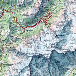 As mentioned before, topographic maps use a system of lines to indicate elevation. Whereas regular maps only allow you to think in terms of length and width, these add height into the mix. It works through the use of what are called “contour lines”. In essence, they are lines drawn that represent an area of equal elevation. So, as you look at a circular hill on a topographic map, for instance, you will see contour lines at different elevations (with exact numbers included on each “index” contour line) all the way up to the hill’s peak. To make it easier to read, most topographic maps use a “contour interval” that is specified in the key (or legend). This allows you to judge the relative steepness of elevation increase. Generally, the less space between contour lines, the steeper the hill or valley is.
Putting it Into Context
Along with the contour lines, topographic maps also include a scale on which to base distances. When a map is made, the whole area is essentially shrunk down proportionally to give you a minimized picture of a large swath of land. Generally, they are shrunk so that one small measurement on the map is equivalent to one much larger unit of measurement on the map. So, for instance, one topographic map might have a key that reads 1:24,000 inches. This means that every one inch displayed on the map is 24,000 inches (or 2000 feet) on the land itself. This method of scaling helps give you an accurate representation of the land you’re currently on.
Putting the Map to Good Use
No matter how well you can read a topographic map, it won’t do you any good in real-life outdoor experience if you ignore the information given. If, for example, you’re looking for a nice, easy hike at ambling pace, you’ll want to seek out areas of the map where contour lines are further apart and elevations remain steady. A hike for good exercise, meanwhile, might benefit from rapid elevation changes. The ingeniousness of the topographic map doesn’t necessarily lie in the pure information it gives – it’s in how you use that information. So, now that you know the basics of what makes these maps unique, don’t hesitate – get outside and use one!